
What do you need for the best farm management program?
As we move towards digital tools, we expect them to be a help first and foremost, not an additional hassle. Simplicity is therefore the most important thing for a farm management application to have. The right apps are designed to minimize the number of clicks required, by putting all the steps in a way that farmers can understand and use, and by providing all the tools they need to make farm management more convenient. We do this by constantly consulting with farmers of all sizes, agronomists, agricultural scientists, and global best practices. What are the specific benefits and opportunities for our Geoface users?
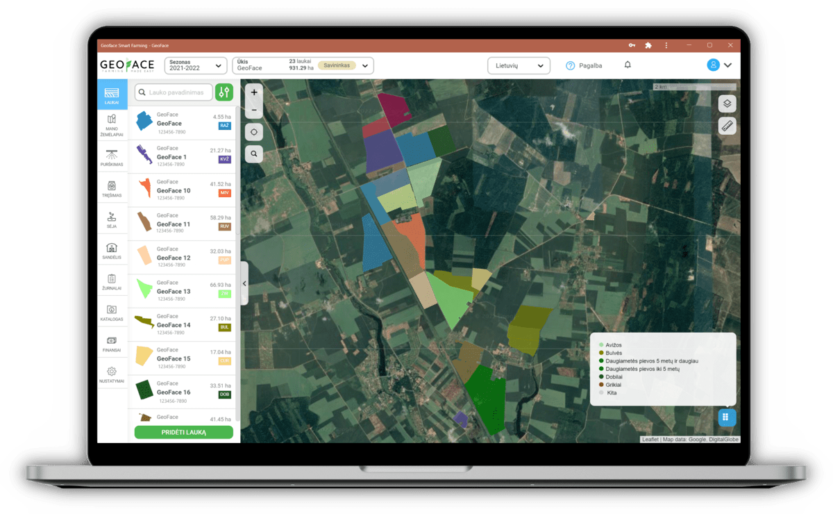
Convenient field contribution
In order to get started with smart agricultural management applications, we are always asked to specify our fields. The most common way to specify fields is to use the “drawing” tool to draw the field boundaries. This method is slow and unattractive. In Geoface you will of course find this method too, but it is much more modern. For example, importing fields from the EAA with a few clicks of a button. Another convenient and interesting way is by selecting the desired fields on the provided map according to the previous year’s
declarations. Geoface offers a total of 6 different ways to contribute fields to the application. From the very first experience of using the application, we want to show that Geoface is different. Geoface is focused on convenience and simplicity.
Field monitoring with FAPAR (NDVI) index
Once the fields have been loaded, one of the most well-known features of such applications becomes available to you – remote field monitoring on a map. A regular satellite map is displayed where you can conveniently mark your fields. Once marked, you can see the area and the block number, and, using the FAPAR (NDVI) index, you can monitor the vegetation status of the field. Using modern technology, satellites, spectral cameras, and sophisticated algorithms, we are able to monitor and record changes in the vegetation of a field every three days. After processing the algorithms, we share the pictures with you, enabling you to monitor problem areas in the field. When you see huge irregularities in vegetation, you can look for problems in the drainage system, in the soil, or elsewhere.
It’s not just fields and their vegetation that you can see on the Geoface map. Geoface allows you to activate drainage schemes, pinpoint your exact location, and save drainage systems by reclaiming their estuaries. You can also use a handy exploration tool where you can mark points in the field and assign photos and comments to them. This allows you to monitor your crops or mark important problems such as stones and potholes and share this information with other farm staff.
Quick and easy task planning
The main function of farm management software is work planning. In Geoface, all types of farm work (sowing, fertilizing, spraying) are planned in the same sequence using a standardized template. Customers find the farm work scheduling to be one of the most intuitive and easiest-to-use features of Geoface. The biggest advantage is the high flexibility to adapt to real farm situations. Our planning is done en masse. Automatically selecting all fields of a single crop, with the possibility to exclude some fields from the work plan.
Another much-loved feature of Geoface is the input of the actual quantity used. On the farm, plans rarely correspond to reality. We have therefore developed a function that allows you to enter the actual amount of material used when the work is finished. When you enter the actual quantities of fertilizer or other materials used, everything will be automatically recalculated. This will record the actual quantities used, recalculate and record the real rates and real costs.
Sowing planning
In Geoface, you choose your seeds and fertilizers from an extensive list of products from all major suppliers. If you don’t find the product you are looking for, you can either add it to the list yourself or inform the Geoface team to add the product you want. In the sowing section, you will find the recommended sowing rates as well as a sowing rate calculator where you can use the seed parameters to get the sowing rate you need. You can also add the required nutrients and micronutrients to the planned sowing.
Fertilization planning and variable rate nitrogen fertilization maps
The list of fertilizers is even more extensive, and you can also add products that you cannot find here. Once you have planned, you will also see the amount of active ingredient per hectare, both for the field and for all the planned works combined – no need for a calculator. Also, all fertilizer applications made are automatically transferred to the fertilizer logs, which you no longer need to keep separately. This log is permanently available and can be downloaded in PDF format.
Using the satellite (FAPAR) information described above, we provide a unique opportunity to fertilize your crops with nitrogen at variable rates. Using sophisticated algorithms and after you specify the total, minimum, and maximum fertilizer rates per hectare, we will recalculate the fertilizer rate for the hectare.